|
Getting your Trinity Audio player ready…
|
When most people talk about the Grand River, they talk about it as a local feature: a place to fish, paddle, walk the trail, or worry about spring floods. Almost nobody talks about it the way Canada actually uses it: as part of a binational freshwater system, a component of Canada–U.S. border architecture, and a corridor where security, environmental protection, infrastructure, and constitutional promises intersect.
If you follow the Grand River from its headwaters to Lake Erie, and then follow the law that is supposed to apply along that corridor, a different picture emerges. The river is not simply “Ontario’s watershed” or “GRCA jurisdiction.” It is the backbone of a promise made to the Mohawks of Grand River that has never been honestly honoured, even as governments and agencies continue to act as though that promise does not exist.
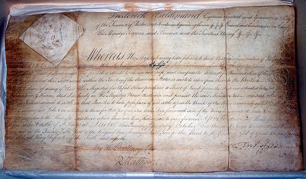
The starting point is the Haldimand instruments. Through the Haldimand Pledge of 1779 and the Haldimand Proclamation of 1784, the British Crown confirmed that Mohawk Loyalists and their posterity would have exclusive use and enjoyment of a strip of land “six miles deep from each side of the river beginning at Lake Erie and extending in that proportion to the head of said river.” This language is not symbolic. It is a riparian formula. Jurisdiction and estate are fixed to the river itself—its banks, floodplains, wetlands, and bed. The river is the reference line; the land grows out of the water.
When Upper Canada was created in 1791, this commitment was confirmed again. The faith of the government was pledged to the Mohawks of Grand River and their posterity forever. Canada later built its institutions—land systems, municipalities, provincial laws, conservation authorities, boundary commissions—on top of that commitment. What it never did was properly integrate Mohawk jurisdiction along the corridor. In practice, the Haldimand estate was treated as though it had quietly merged into ordinary Crown land, despite the absence of any lawful surrender or extinguishment.
Over the twentieth century, a second structure was layered over the first. At the provincial level, the Grand River Conservation Authority was created to manage flooding, erosion, dams, reservoirs, and hazard lands across the watershed. GRCA maps determine where people may build near the river, issue permits for bank and floodplain works, and shape municipal zoning and official plans. For residents near the Grand River, GRCA is often the primary gatekeeper.
From Queen’s Park, this appears to be routine watershed governance. From the Mohawk Nation’s perspective, it is a statutory agency exercising control over the same corridor pledged in perpetuity to Mohawk Loyalist posterity, without surrender or shared governance. GRCA staff may act in good faith, but their authority rests on the assumption that Mohawk jurisdiction can be ignored.
Federal structures extend this overlay further. The Grand River drains into Lake Erie, one of the boundary waters between Canada and the United States. These waters are governed through federal arrangements concerning water quality, levels, diversions, infrastructure, and emergency response. Flood planning, spill response, dam safety, and cross-border incidents all proceed on the assumption that Canada speaks as a single, internally settled jurisdiction. Along the Haldimand corridor, that assumption has never been resolved.
This gap became explicit when the Surveyor General’s office was asked about it directly. We were told that the Haldimand Proclamation “was not a consideration” during the negotiation of Canada–U.S. boundary water arrangements in the early 1900s, around 1908. The explanation was straightforward: the Haldimand Tract was viewed as “entirely within Canada” and therefore irrelevant to an international water treaty. Mohawk rights were treated as a domestic issue that did not need to be accounted for when Canada dealt with the United States.
That logic depends on treating the Haldimand estate as a boxed-in parcel of land that stops short of Lake Erie. That is not what the text creates. “Six miles deep from each side of the river beginning at Lake Erie” carries the Mohawk estate to the point where the river meets the lake. Under common-law riparian principles, abutting owners have defined rights and standing, including access to water and the ability to object to interference with flow or damage caused by upstream or downstream works. In that light, the Haldimand Tract is not an internal enclave. It is part of the shoreline Canada relies on when it deals with Lake Erie as an international boundary water.
The disconnect becomes even clearer in the riverbed itself. Brantford, like other municipalities along the Grand River, continues to plan and build bridges framed as routine infrastructure projects. But bridges are not abstract crossings. They require piles, piers, cofferdams, demolition of old foundations, and disturbance of sediments. They occupy the bed of the river.
No clear chain of title has ever been produced extinguishing Mohawk interests in the riverbeds within the Haldimand Tract. Instead, the beds have been treated as Crown property by default, based on the general rule that navigable riverbeds vest in the Crown. In most Ontario contexts, that assumption goes unchallenged. In the Haldimand corridor, it collides directly with a river-centred estate pledged in perpetuity.
When Brantford undertakes in-water works, it acts on the assumption that the Crown may authorize those works without Mohawk consent. From the Mohawk perspective, these are occupations of a national estate that has never been surrendered. Bridge piers are not merely “over” the river; they alter flow, scour, ice dynamics, fish habitat, and sediment movement. In any honest legal framework, they would require the explicit consent of the nation whose estate lies beneath the water.
This is why the Mohawk Nation has challenged Brantford and other authorities undertaking in-water bridge works within the Haldimand corridor without Mohawk agreement. The issue is not whether bridges are needed. It is which law is being respected, and whose rights in the riverbed are being acknowledged or erased.
These local issues tie directly into national security. In correspondence with the Minister of National Defence, Bill Blair, we have made clear that unresolved Mohawk jurisdiction along the Grand River and its shoreline is not merely an “Indigenous rights” issue. It affects flood response, dam failures, industrial spills, cross-border movement, and climate-driven emergencies. Planning that quietly deletes Mohawk jurisdiction builds a structural blind spot into Canada’s risk management.
In response to this long-standing denial, the Mohawk Nation of Grand River has not remained passive. We have been building and documenting the governance system that should have existed all along, and placing it formally on the record. That work is beginning to move the other side of the system as well. After more than a decade of written notice, Ontario’s land-titles leadership has recently re-engaged. The office responsible for the Land Registry System has confirmed that our correspondence is under detailed review with the minister and has opened the door to discussing next steps. This is no longer a dormant historical grievance. It is an active question within the machinery that records title.
For people living along the Grand River, this matters. Homeowners, municipal officials, brokers, lenders, and residents are entitled to ask their governments how Haldimand-based Mohawk interests are being addressed. This is no longer only a Mohawk conversation. It is a public one.
A central part of our response is the Mohawk Environmental Protection and Sustainability Initiative (MEPSI). MEPSI is our national environmental directive for the Haldimand corridor. It affirms that the territory described in the Haldimand Proclamation—including banks, floodplains, wetlands, riparian zones, and the riverbed—is subject to Mohawk law and environmental standards. It establishes rules for land use, conservation, restoration, and climate adaptation grounded in Mohawk obligations to the land and water.
MEPSI is an operational tool. It provides a structured framework for reviewing projects, permits, and emergency plans affecting the river, whether proposed by municipalities, conservation authorities, or provincial and federal agencies. If a subdivision moves toward the river, fill is placed in a floodplain, a dam is modified, or a bridge pier is driven into the riverbed, MEPSI requires that Mohawk environmental standards be part of the decision. It asserts that the people whose estate was pledged along this river must have a say in its future.
MEPSI operates alongside a broader framework of Mohawk governance. The Mohawk Nation Housing Initiative addresses housing recovery and development for Mohawk Loyalist posterity. The Mohawk National Vehicle Registry and Grand River National Driver Insurance Policy assert transportation authority. The Mohawk National Transportation and Safety Initiative organizes traffic and public safety within our jurisdiction. Mohawk driver and resident identification establishes recognized residency and citizenship within the corridor. Our diplomacy and sovereign immunity initiatives define how we relate to other governments on a government-to-government basis.
Together, these instruments state a simple fact that Canadian systems have avoided for generations: the Mohawks of Grand River remain here, still carrying the obligations of the Haldimand corridor, and are rebuilding the institutions needed to meet those obligations.
For those who live, work, or build along the Grand River, this is not a call to panic. It is a call to see the full structure you inhabit. Beneath conservation authority lines and zoning maps lies an older jurisdiction tied to a river-centred estate that begins at Lake Erie and runs to the headwaters. MEPSI and related directives bring that jurisdiction back into the open.
For municipalities and agencies, the message is not that bridges cannot be built or flood controls maintained. It is that these actions cannot be carried out honestly while treating Mohawk jurisdiction as nonexistent. Ignoring it shifts risk onto future homeowners, courts, and communities.
For Ottawa and Queen’s Park, the Grand River tests whether constitutional commitments matter when they are inconvenient. Canada cannot claim rule-of-law credibility while managing a treaty-defined corridor as though the treaty never existed.
For residents, the steps are practical: pay attention when “Grand River” and “Haldimand Tract” appear together; ask what standards govern new projects near the water; understand that property along this corridor carries a deeper legal story than a single deed reflects.
We are not trying to freeze the river in time. We are trying to bring the promises that built this place back into the decisions that shape its future. That means insisting that in-water works recognize whose estate they touch. It means bringing Mohawk environmental law alongside provincial regulation. It means treating the Grand River not as a planning constraint or local amenity, but as a living corridor where Canada’s infrastructure, security, and moral obligations converge.
Canada cannot protect what it refuses to see. The work ahead is to see the Grand River clearly—not as a blue line on a map, but as a pledged corridor of land and water that still carries the weight of a promise. The Mohawk Nation of Grand River is rebuilding its laws and registries. The question now is whether the governments that built themselves on top of that promise are willing to finally act as though it was real.
Leave a Reply